Trail Mountain bike Gemeinde Gaschurn - kops - Photo
 Didier81
Didier81

User

© OpenStreetMap contributors
Length
Length
4.5 km
Max alt
Max alt
1450 m
Uphill gradient
Uphill gradient
395 m
Km-Effort
Km-Effort  
8.4 km
Min alt
Min alt
1051 m
Downhill gradient
Downhill gradient
1 m
Boucle
Boucle
No
Creation date :
2023-08-30 10:10:26.16
Updated on :
2023-08-30 15:45:45.574

(0 Reviews)

Mountain bike
Mountain bike
4h04
Difficulty : Easy

Scan this QR Code to open this trail in the SityTrail application

FREE GPS app for hiking

Logo SityTrail SityTrail

IGN / Geographical institutes

Download SityTrail from the App Store Download SityTrail from Google Play

Logo SityTrail SityTrail World

The world is yours!

Download SityTrail from the App Store Download SityTrail from Google Play Download SityTrail on Huawei AppGallery

About

Trail Mountain bike of 4.5 km to be discovered at Vorarlberg, Bezirk Bludenz, Gemeinde Gaschurn. This trail is proposed by Didier81.

Elevation profile

Photos

Positioning

Country:
Austria
Region :
Vorarlberg
Department/Province :
Bezirk Bludenz
Municipality :
Gemeinde Gaschurn
Location:
Unknown
Start:(UTM)
580825 ; 5202249 (32T) N.

Trails nearby

Trail Touring skiing Gemeinde Gaschurn - Raid j1 silvettra - Photo
Touring skiing
lbourmau

Touring skiing

Gemeinde Gaschurn, Vorarlberg, Bezirk Bludenz, Austria
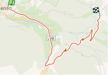
17.9 km | 39 km-effort
4h 20min
No


Close
My subscriptions